theunfinishedtask.com
http://theunfinishedtask.com/bm/about-png-papua-new-guinea/index.shtmlPapua New Guinea
[an error occurred while processing this directive]Edit page New page Hide edit links
OVERVIEW
The Land:
It covers an area of 462,840 sq. km (178,704 sq. miles).
Land mass within PNG territory = 452,860 sq. km.
Water within its territory = 9,980 sq. km.
Land use: 0.49% arable with 1.4% used for permanent crops.
PNG has 4 regions and 20 provinces, and is slightly larger than the state of California.
The climate is tropical with the Northwest monsoon from December to March, and the Southeast monsoon from May to October. There are slight seasonal temperature variations.
PNG has one of the world’s largest swamps along its Southwest coast. The terrain is mostly mountainous with coastal lowlands and rolling foothills. The elevation goes from 0 meters at the Pacific Ocean to 4,509 meters at the top of Mount Wilhelm.
Natural Resources include: gold, copper, silver, natural gas, timber, oil, and fisheries.
Natural Hazards entail active volcanism, PNG is situated along the Pacific “Ring of Fire”, earthquakes, mudslides, and tsunamis.
Papua New Guinea gained its independence as a country in 1975.
Governed by a Constitutional Monarchy
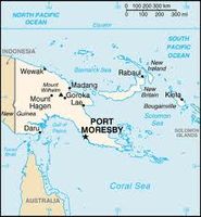
Capital of PNG = Port Moresby
Papua New Guinea is a group of several islands located North of Australia.
The People: PNG has an indigenous population and is considered one of the most heterogeneous in the world. It has several thousand separate communities (most containing only a few hundred people), which are divided by language, customs, and traditions. These separate communities are so divided that it makes governing difficult, leading to conflicts and lawlessness.
Population = 6,057,263 (July 2009)
Five main ethnic groups (Melanesian, Papuan, Negrito, Micronesian, and Polynesian)with hundreds of indigenous people groups.
Official Languages include: Tok Pisin, English, and Hiri Motu. Also 860 indigenous languages are spoken (over one tenth of the world’s total). Note: Tok Pisin is a creole language and is widely used and understood; English is spoken by 1%-2% of population; Hiri Motu is spoken by less than 2%.
Literacy= 57.3% of population being age 15 or older can read and write.
Population Growth Rate= 2.069%
Birth Rate= 27.55 births/1,000 population
Death Rate= 6.86/1,000 population
Infant Mortality Rate= 45.23 deaths in 1,000 live births.
Risk for major infectious diseases= very high
Food and water borne diseases– bacterial diarrhea, hepatitis A, and Typhoid Fever.
Vector borne diseases– Dengue Fever and Malaria
Highest incidence of HIV/AIDS in the Pacific Region. Also the 4th country in Asia Pacific Region to fit criteria for generalized HIV/AIDS epidemic. (1.5% of adult prevalence rate for HIV/AIDS – 54,000 people have this disease.)
